

Drive out from the lake at Agawa Bay along a road that climbs
sharply as it rides the edge of the great hill that makes the northern end of
the bay. Up and 'round and up you go and you think you'll have to come down
again to get to the pictographs 'cause no one's crazy enough to make a sacred
place on the lake that you have to walk down to from here, not even Indians who
knew a thing or two about walking the hills.
Mostly, now they're in their cars too.
Then there's a sign to the left, "Agawa Rock". It's somewhere
down there.
Down and round and down you go, a small road run through close meadow
and smallish woods and I'm not sure it's all cut over and grown back different
but it's a reasonable bet. Or maybe that's just what it's like along the sides
of precipitous hills hard to the lake -- jutting hummocks of stone breaking patches
of meadow fringed by narrow trees, everything at an angle, the whole place often
shrouded in fog.
Come round a downhill curve and the small road abruptly ends with a
forked tail. Right leads to Sinclair Cove and a boat ramp. A splendid natural harbor,
intimate and fair protected from the caprice of Superior. It's easy to picture a
half dozen Canot du Maitre put up for the night
and a glittering necklace of small fires reflected upon the water, what with
camp put up tight on so narrow a shore.
Take the left, to Agawa Rock. No need for imaginings today.
The parking lot is nondescript. A simple informational kiosk. An
eco-friendly privy, hidden by trees. But there're no picnic tables anywhere and
the lot has ample space set aside specifically for buses, so there's that. This
morning, the place is near to empty.
There are two trails. Both lead down.
One is called by some a "shortcut". I've taken it once, which
was enough. Having just counted them, a fellow traveler told me how many steps
there are -- narrowly cut straight through nearly perpendicular walls of black granite,
dripping with moisture. An amazing set of stairs, like steps carved out by an
unknown hand at the beginning of history. I don't remember exactly how many the
traveler said. A whole bunch, by any measure.
The 2nd trail is more typical in that it follows the natural slope of
the place along small switchbacks using stones and roots for stairs, construct
relegated mostly to trail stabilization and maintenance. The thing is still
steep but hardly precipitous and a damned sight easier to make whether hauling
an abundance of gear or just unused to walking the hills.
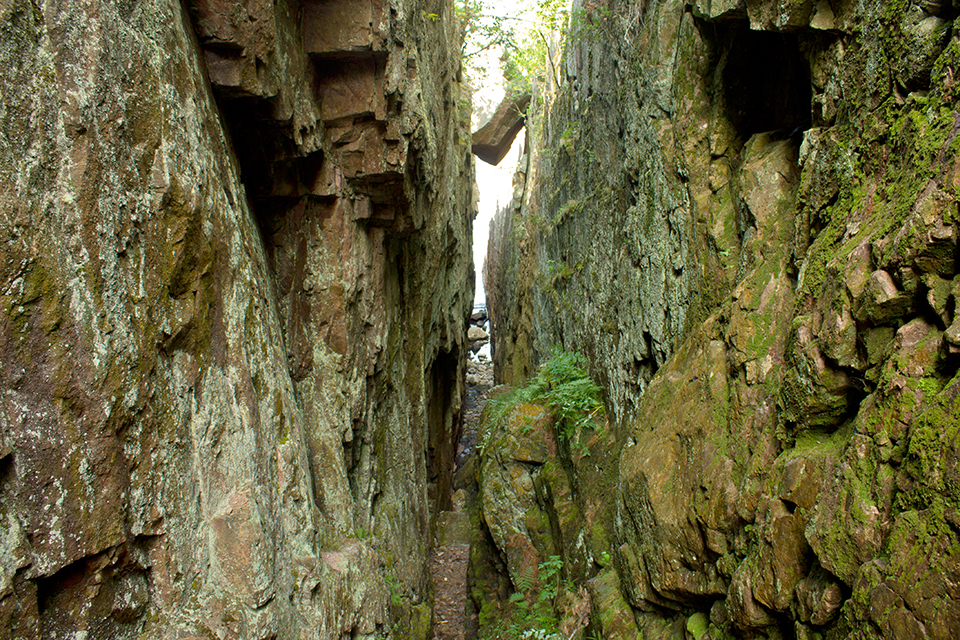
Down and round and down you go, until you think you must be there because at the bottom where
these two trails nearly meet, the landscape turns mad. Funhouse mad, with
irregularly sloping ground hosting tilted trees
riding wildly between tumbled stone, everything hemmed in by sheer rock
walls.
You've entered the realm of the volcano. And once there, intuitively
understand why this place has been sacred pretty much forever.
2.5 billion years ago, molten rock formed these granite walls. One
billion years ago, pressure fractured granite, allowing lava free flow through
these cracks in the world. There was no lake, then.
In time, this became the place we see today, much the same as the
Indians saw when first they arrived some thousands of years ago, to a landscape
of such powerful, evident
significance that it could only have been the construct of Gods.
And still the trail leads down. Not so steep as before but across the
mad terrain, mercifully freshened by the breath of big water. You're close. You
can feel it.
Finally, the trail leads to an outcropping of tumbled rock overlooking the
lake...

From there, only a few steps remain to clamber down...

Where, once you gain a tenuous foothold on the sloping shelf, along the
sheer rock wall facing the lake you find such treasure as this:

And it occurs to you if you didn't already know, our modern
perspective is skewed. These were meant to be viewed from the lake, to be
visited from the lake. Meant for Superior to see them and for Mishipeshu to see
itself, honored in the reflection of human art for as long as art and memory
can last.

Superior was the only highway. No one walked down from the hills. When ancient
peoples first crossed open water and came to this rock, all they had to do was
go up and round just a bit, to recognize a sacred place.
*
The art at Agawa Rock tells a story.
As part of that narrative there's supposed to be a site corresponding
to Agawa near the Carp River in the Porcupine Mountains of Michigan. In Henry
R. Schoolcraft's writings appears a drawing by Seth Eastman of those
pictographs, copied from birch bark scrolls given Schoolcraft by the Ojibwa
shaman Chingwauk. Unlike Agawa, this site has never been 'discovered'.
When Johnny & Heather & I were young and regularly bustering
around the Porkies, we determined to find this these 'lost' pictographs. Of
course, we never did. When I'm hiking around the Porkies this October during my Artists in Residence stay, I'll at least keep an eye out if not my hopes up,
old habits die hard.
But there'll be no road leading down to the site. No parking lot, with
room for buses or otherwise. Most folk think that in all likelihood, the
pictographs near the Carp River have long since disappeared -- worn with time, grown
over by wilderness or committed to rock now crumbled to pieces with time. Maybe
even stolen with hammer and chisel by thieves, in some circles called
"collectors".
What's known is that Chingwauk spoke the truth about Agawa.
I like to believe that if the art said to be a 'half day's march"
near the Carp river that flows through the ancient Porcupine Mountains ever did
exist it still does. Whether in fact or certainly in spirit, as sacred places
don't die just because red ochre fades.
And I've come to believe that this sacred place is no need of discovering.
Because (as long as we're imagining) those folk who know a thing or two
about walking the hills...they're likely protecting the place already and with
the help of their ancestors too, no tourists need apply.
No comments:
Post a Comment