Thursday, August 25, 2022

Superior's North Shore, Revisited – Turning South


True North is out there.


Way out there, beyond the curvature of a very hard Earth.


Lake Superior Provincial Park

If Pukaskwa is the wildest place I've ever visited across all of Superior, on its northern shore Lake Superior Provincial Park is my most beloved.

There, Heather and I have made lasting memories. Woven the sort of magic golden threads that sustain a spirit over the course of a long life, until life and maybe spirit too, is no more.


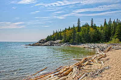
Like how on our first visit we were so happy to find ourselves camping just steps from the beach that we ran out into the lake and frolicked like ecstatic children in a pounding surf.

The lake lifted us up, hurled us toward shore, rolled our helpless bodies across gravel and sand, then yanked us back into its watery grasp. Over and over and over again.

We laughed like we'd live forever. Then when exhausted, we lay on the sand listening to the big lake roar beneath a glorious autumn sun. It was a fine day to be young.


What that bucolic scene up there doesn't tell you and we didn't discover until the next day is that just beyond where we'd embraced youthful abandon, lake bottom drops pretty much straight off to who the hell knows where.

Had Superior chosen to carry us away and set us loose over rolling green deep water, it's possible that one or both of us would've have drowned.

On a later trip, we sat transfixed in our comfy camp chairs on that same sand and watched a fireball cleave ink black night sky, trailing a fiery tail of sparks behind. The fireball slashed over the lake then disappeared at the western horizon, out toward where Minnesota lurked unremembered.

Having no place else in the world to go and with no ready way to get there anyway, Heather & I spent the next fifteen minutes or so waiting on the great dark wave to maybe wash us off the face of the earth and onward toward oblivion.

It didn't. So there's another true north sojourn when we didn't die.


Two of my favorite sites to photograph around all of Superior are in the park named after it.

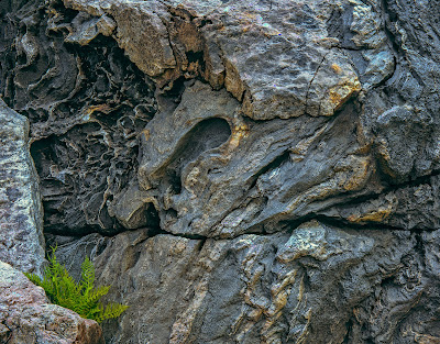
At Pinguisibi, ancient rock seems to flow like water because it used to be molten fire.


Life clings stubbornly to the cracks.


Katherine Cove and its freshwater 'tide pools' at first light are dependably  photogenic as anywhere I've been on the lake. It doesn't matter the place is unchanging. Early morning light that falls upon it always is.

Then and there, life exists in the moment and time is made fluid by sight and sound and breath of fresh air.


And there's still ample opportunity afterwards, to explore human notions of permanency.


Agawa

From the relative comfort of camp, Agawa Rock is hidden away out there.

Not so far out there as the crow flies, but still. Those slopping hills aren't as gentle as they look, when you're on them.


Near the bottom of one of the hills, the Earth is cracked.


Off to the left and down still more hill is a vertical rock wall with a tiny sloping ledge hard to the freshwater sea. If the place was just more anonymous Superior shoreline, from the land you'd never guess it was there.

Yet on that wall descendants of those who first came to the place left this, for future consideration:


With red ochre on rock, these people said I am here.


And other things, too.


The ledge along Agawa Rock runs fast into the big lake. That ledge is almost always wet.


Look close and you'll see lengths of rope trailing off into the water, secured to the rock by great bolts set into it. That's so that after you've been careless and Mishipeshu grabs you, maybe you'll not end up sleeping with fishes after all.


Should the Great Lynx claim you anyway, consider that as partial payment for all the copper your ancestors removed from Superior, over which that great spirit in the water once stood guard.

Today, no one does.


In any event, at Agawa and most everywhere else along Superior's sprawling north shore, you should remember to try and not die. Because from Minnesota to the Soo is mostly what we call 'wilderness.'

By any other name that spells utter indifference to human existence and that includes you.

I suppose that indifference is why wilderness was once considered the Devil's province, and so naturally our duty to try and tame. And why today's wildest remnants that evaded taming still both awe and frighten us, when we traverse the real world as tourists.


It's said that in the Porcupine Mountains somewhere near the mouth of the Carp River is a rock art site corresponding to distant Agawa. This portion of Superior's south shore is on my home turf:


There's a great deal of open water between distant Agawa and there.

But related pictographs so far removed would speak directly to the transgenerational interrelationship of peoples and cultures across the entire Superior basin. Always a valuable concept to think on, even in historical hindsight.

Perhaps the rumored Carp River site is a bunch of hooey. Just another story in which truth/untruth is lost to the river of time, with no one alive today able to say for sure.

I stayed there once and I sure didn't find it.


Or maybe pictographs do exist at the Carp in the Porkies and those folk who best understand their meaning have for hundreds of years successfully shielded them from prying white eyes by exerting honest ownership over the larger portion of the region's human story that their enduring presence rightfully earns them.

Well, one can always dream. Superior's true North Shore is made for such.

In any event, it's now time to head farther south, toward home.


If not exactly to where the Carp and the Porcupine play, then at least in that general direction…


Thursday, August 18, 2022

Superior's North Shore, Revisited – True North


The Keweenaw Peninsula rises from Lake Superior somewhere out there:


Way out there, where Copper Harbor lies hidden beyond the curvature of Earth.

Back on the Trans-Canada Hwy, the next stop is as far north as Superior's shore gets. That'll be some one hundred and fourteen plus road miles north/northeast from Grand Portage, well past the reach of Minnesotan branding.


Nipigon

Sometimes, you'll hear Lake Nipigon called the 'sixth Great Lake'. It's mighty big, but I don't buy that branding either. Still, via the once mighty Nipigon River, it's Superior's largest tributary.

The river pours the region's lifeblood into the freshwater sea near a place that used to be known as 'Red Rock House,' named for a fur trading post. The town is now and presumably forevermore called Nipigon.

I knew the river by reputation before ever going anywhere near the north shore. That's where in July of 1915, a Dr. Cook caught (what's still maybe) the World's Record Brook Trout.

Regardless, it was one big brookie. The stuff of northwoods legend. That tale reached me as a young boy, hundreds of miles south on a distant prairie.


Today, you can't even see the skin mount they made of the actual fabled fish. That burnt in 1990 when the Historical Museum that housed it caught fire. But there's a replica don't 'cha know, which you'll find in the restored museum.

After passing through the small town with the river's name any number of times on my way to somewhere else, in 2012 I finally headed upriver.


Broad and wide, the Nipigon is about what you'd expect from a once wild river that's been damned. The rapids where Dr. Cook caught the famous fish have long since been swallowed by deep water, or I'd have gone all the way north just to sit under a tree next to them.

Like so many fish that start at the big lake, I made it to the first of four major dams.


Having seen more than enough, I turned tail and ran. That's the farthest north on this continent I've ever traveled.


Pukaskwa National Park


Established in 1978 and encompassing some 725 square miles, Pukaskwa is the wildest place I've been. Maybe, the wildest place I ever will.

There's one thin road out of Marathon that ends in a loop around a campground near Superior and a visitor center on the Pic River at Hattie's Cove. Same thin road out, northbound.

In the rest of the vast park, you're on your own.


So impressed was I after our first visit I thought a canoe trip on the White River starting in the town of White River (surprised?) and paddling through Pukaskwa's wild heart would be a most awesome way of getting to know the real place.

No doubt, it would have been that.


Except it meant 50+ miles with 21 portages along the way, over what had to be an exceptionally well-planned and trained for seven days, minimum. Because once you've traversed the wilderness and reached Superior alive (provided you did), from the mouth of the White River you've still got some miles of open water to paddle before reaching safe harbor.

In other words, should the wind be onshore at the end of the daunting, week long river journey, you're stuck there at the hard edge of nowhere for who knows how long.

Reliant on only your wits for the duration, because the canoe won't go.

In case you're wondering what that'd sound like:


Sounds a lot like like 'Hahaha, stupid canoeist' to me.

After the Bear Story, my ardor to confront unbound wilderness armed with only my wits and a canoe died a sudden death. 

Flat water turned out to be plenty magical anyway. And there's now a hydroelectric dam on what was the fully wild White River, so neither I nor the river are what we used to be.

Ah, well.


They say that among the collection of debris pictured below, if you look hard and long you'll maybe find a vintage log or two that still bears the brand of its original owner. It's said such logs remain the owner's property in perpetuity, no matter where you find them.

That's what they say.

I decided long ago that even rolling so much as an ankle at Pukaskwa wouldn't be smart, so never ventured to look. But from safe vantage, it seems like an entirely reasonable version of perpetuity to me…


I've been privileged to stand on a razor rock edge between mighty Superior and its wildest land, where both tossed me boreal forest air kisses while I gazed vaguely south beneath an brilliant sky.


That's no small thing in a life.


As is true of everywhere else along the big lake, before the trappers, loggers, miners, fisherman and other tourists, there were First Peoples.


The next town east out of formidable Pukaskwa is the birthplace of Winnie the Pooh and so much for Indian Country today. Maybe have lunch in White River.

Then when back on the road headed toward the Soo and after a few hours of a whole lot of nothing passing by you get road weary, perhaps you'll think that before white folk cleaved their way through it - leaving little islands of civilization named after rivers and where cartoon bears were born - there was no lasting culture here at all.


No matter. Voyage on and you'll soon enough be disabused.


Wednesday, August 3, 2022

Superior's North Shore, Revisited


A great wilderness rises out of Lake Superior, somewhere out there:


Way out there, beyond the curvature of Earth.

From the beginning, fall has been our preferred Northwoods season. The nights are cool, biting bugs are down. The forest comes ablaze in autumn dress and light is often sublime, if with some frequency chill.


So naturally, the first trip Heather & I dared take up and over Superior was in September. Then at the end of a real long day on the road we found the place we'd planned to stay closed for the season. It's a different world, up there.

Going forward we adjusted and have treasured our summer visits since. But never have I explored the region with such frequency and depth as during 2012, when I logged now uncountable miles during multiple trips along the Trans-Canada Highway on my own.

This summer we'll head west to east, pausing here or there for another look. Better to make a start in Minnesota I think, not an end.

*

Minnesotans like to call their admittedly bucolic sliver of Superior "the North Shore." Except any fool with a map can see it's no better than Northwest. Such is the importance of branding to sustainability, I guess.


Take Hwy 61 out of Grand Portage MN and soon enough you reach a manmade border. No lengthy portage necessary, lest you've run afoul of some law or the other. First stop along the way from there is the city of Thunder Bay.

Thunder Bay's nice enough I suppose, but isn't yet sufficiently post-industrial for me. There, mighty Superior remains largely inaccessible – cut off from casual contact by rail lines and remnant industry, just as was the case in nearly every city on the Great Lakes, once upon a time.

We'll stop at Old Fort William in Thunder Bay just long enough for me to say yet again that of all the places I've been, the canoe shop where craftsman make birchbark canoes much like Voyageurs did, has consistently provided the richest, most reliable interior light of any place I know.

There's manifest integrity in that light. Damned glad to have worked it as often as I have, first time to last.


Leave lingering industry and reconstructed history behind, then after a few miles of relative nothing you come to the Sibley Peninsula. Sleeping Giant Provincial Park is there. Detour as far south as the road through it goes and you'll spy the old Silver Islet Mine.

In this little spit of rock poking out of the freshwater sea is a flooded hole. From within that hole, men scabbed silver out of stone buried deep beneath a dark, water-bound wilderness.

What a miserable, dangerous job that was. Could they ever have paid me enough? I think not. Still, times and sometimes collective needs must, then folk risk lives to meet them.


Back on the Trans-Canada Highway it's not so long as the crow flies before over your shoulder on a good day, perhaps you'll see why First Nations People named the sweeping mesa you just left for the spirit Nanabijou.

That's the Spirit of Deep Sea Water to you and me, now turned to stone because the secret location of the silver under the little flooded rock was once disclosed to white men, who then spirited away as much precious metal as was profitable, right until the day it wasn't.

Because that's what conquering white folk did, and many people all over the world still must.


Some miles of slowly rising terrain northeast from sleeping Nanabijou, rests another Ojibwa spirit forever consigned to rock.

From the accessible upper edge it's hellaciously difficult to photograph Ouimet Canyon and I've never been entirely successful. It's said the canyon's so steep and deep that the undisturbed flora and fauna living along its bottom are more typical to Hudson's Bay, yet another 1,000 km or so still farther to the north.

Ouimet is considered a Canadian national treasure so rare that travelers are forbidden from hiking in to see for themselves. Not sure I could make it all the way down and back these days anyway and am content to know it's there, protected by law, both natural and not.


At the end of the road out of Ouimet, hang a left and you're well on your way to Superior's true north. It's still a far wild piece from there to the distant and civilized Soo, with only intermittent good & services available between. So be prepared.

The Trans-Canada Hwy up and over the north shore of Lake Superior is among the continent's greatest drives.

Were it always easy and/or routine, that simply wouldn't be true.